The weather is back!
Yippee! Now I may have something to write about. I have found the last few months of the drought rather depressing with no real weather to speak of and certainly no real fishing to speak of either, but things may be on the right path now, God willing.
It has rained every day so far since Saturday 28th April and looks like it is set to continue for the next couple days. Yesterday Burnie was hit by extremely strong winds around 9am. This is the Advocate article:
BATTEN DOWN More on the way By BEN WILD
WINDS caused chaos on the Coast yesterday, smashing signs, breaking windows and tearing a brick wall loose, and the Bureau of Meteorology predicts gusts will be stronger today.
Trees were blown down, power cut to residents and Coasters in some areas and the thousands at Agfest were left wondering what had hit them.
Somerset was the worst hit, with many locals labelling the winds that tore through town at 9am a mini tornado.
The Somerset Hotel lost two signs, the Beijing Chinese Restaurant suffered a broken front window and the Somerset Hardware store had its awning ripped from the building and sent slamming into a neighbouring building, through a fence and onto the road.
The wind even destroyed a wall at a house in Pelissier St.
Police received reports of trees on the road in Wiseman St, Burnie at 9.39am, Olivers Rd at West Ulverstone at 10.56am and in Main St, Wilmot at 9.30am.
The sign above the United Petrol station on Mount St in Burnie was thrown to the ground and smashed over the road and footpath.
Bureau of Meteorology senior forecaster Lance Cowled said the weather was due to a cold front passing across the State.
"It's associated with strong upper winds that were able to penetrate to the surface," Mr Cowled said.
"We expect further winds to develop overnight," he said yesterday. He said the wind today would be stronger than it was yesterday.
Winds gusting up to 85km/h were recorded at Sheffield and gusts just shy of 80km/h hit Devonport.
Aurora was kept busy as the stormy weather cut power to customers in the Ulverstone and Railton areas from just before 10am to 11.10am.
At the same time, windborne material hit powerlines and cut power to the Agfest site at Carrick along with another 1500 Aurora customers. Agfest was back up and running by 11am.
This is the information I sent to the BOM in my role as a Storm Spotter:
Not sure if you already have had some reports or not, but I did observe a short wind event in Burnie around 9am this morning. The winds hit with-in seconds and lasted about 2 minutes. From what I could see from inside my office, the winds appeared severe. I took a quick drive around town after hearing chain saws in action and there are quite a few trees blown down. Some were snapped off midway up the trunks, but they were wattle trees. Others were just stripped of bark. Also I have had reports of windows being blown out and the repair people are saying it could be days before they get everyone fixed up due to the number of calls.
From my limited knowledge and observations, it appears to me that the winds were ‘straight line’ in nature. I saw nothing to suggest any tornado activity. The damage appears widespread, but in isolate pockets around the town.
As a follow up to the Advocate article:
Although I never seen the damage at Somerset, I’m personally a little dubious about the “mini tornado” statement. Have the Bureau been able to confirm this claim or is it just media excitement? The pattern I’ve seen with ‘small’ tornados on the coast over the last 20 years of weather observing is that they seem to occur in situations where the only violent wind is associated with the tornado itself while elsewhere it can be virtually calm. What I observed yesterday was more like “channels” or “tunnels” of very strong straight line winds. Of course, there is a chance that a ‘mini tornado’ could have been in the mix, but from what I observed I would have to doubt the claim myself at this stage.
Anyway, whatever the case, it was exciting to see the weather “back” again after a long break.
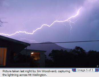
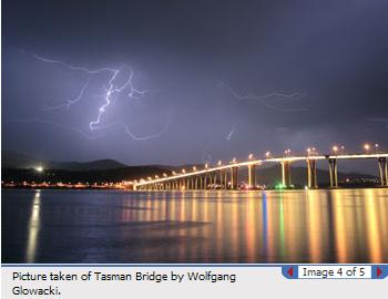
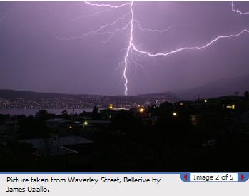
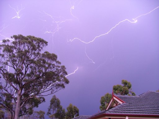
Today has seen a strong Westerly stream form with many fronts embedded, which more like what we should see for this time year. Last night there was a little thunderstorm activity around the coast but most was further East.
Lets hope there will more to write about from now on in.
END:
It has rained every day so far since Saturday 28th April and looks like it is set to continue for the next couple days. Yesterday Burnie was hit by extremely strong winds around 9am. This is the Advocate article:
BATTEN DOWN More on the way By BEN WILD
WINDS caused chaos on the Coast yesterday, smashing signs, breaking windows and tearing a brick wall loose, and the Bureau of Meteorology predicts gusts will be stronger today.
Trees were blown down, power cut to residents and Coasters in some areas and the thousands at Agfest were left wondering what had hit them.
Somerset was the worst hit, with many locals labelling the winds that tore through town at 9am a mini tornado.
The Somerset Hotel lost two signs, the Beijing Chinese Restaurant suffered a broken front window and the Somerset Hardware store had its awning ripped from the building and sent slamming into a neighbouring building, through a fence and onto the road.
The wind even destroyed a wall at a house in Pelissier St.
Police received reports of trees on the road in Wiseman St, Burnie at 9.39am, Olivers Rd at West Ulverstone at 10.56am and in Main St, Wilmot at 9.30am.
The sign above the United Petrol station on Mount St in Burnie was thrown to the ground and smashed over the road and footpath.
Bureau of Meteorology senior forecaster Lance Cowled said the weather was due to a cold front passing across the State.
"It's associated with strong upper winds that were able to penetrate to the surface," Mr Cowled said.
"We expect further winds to develop overnight," he said yesterday. He said the wind today would be stronger than it was yesterday.
Winds gusting up to 85km/h were recorded at Sheffield and gusts just shy of 80km/h hit Devonport.
Aurora was kept busy as the stormy weather cut power to customers in the Ulverstone and Railton areas from just before 10am to 11.10am.
At the same time, windborne material hit powerlines and cut power to the Agfest site at Carrick along with another 1500 Aurora customers. Agfest was back up and running by 11am.
This is the information I sent to the BOM in my role as a Storm Spotter:
Not sure if you already have had some reports or not, but I did observe a short wind event in Burnie around 9am this morning. The winds hit with-in seconds and lasted about 2 minutes. From what I could see from inside my office, the winds appeared severe. I took a quick drive around town after hearing chain saws in action and there are quite a few trees blown down. Some were snapped off midway up the trunks, but they were wattle trees. Others were just stripped of bark. Also I have had reports of windows being blown out and the repair people are saying it could be days before they get everyone fixed up due to the number of calls.
From my limited knowledge and observations, it appears to me that the winds were ‘straight line’ in nature. I saw nothing to suggest any tornado activity. The damage appears widespread, but in isolate pockets around the town.
As a follow up to the Advocate article:
Although I never seen the damage at Somerset, I’m personally a little dubious about the “mini tornado” statement. Have the Bureau been able to confirm this claim or is it just media excitement? The pattern I’ve seen with ‘small’ tornados on the coast over the last 20 years of weather observing is that they seem to occur in situations where the only violent wind is associated with the tornado itself while elsewhere it can be virtually calm. What I observed yesterday was more like “channels” or “tunnels” of very strong straight line winds. Of course, there is a chance that a ‘mini tornado’ could have been in the mix, but from what I observed I would have to doubt the claim myself at this stage.
Anyway, whatever the case, it was exciting to see the weather “back” again after a long break.
Today has seen a strong Westerly stream form with many fronts embedded, which more like what we should see for this time year. Last night there was a little thunderstorm activity around the coast but most was further East.
Lets hope there will more to write about from now on in.
END:
posted by Andrew at 9:39 AM
0 comments
![]()


